Montchavin piste Route des Bauches
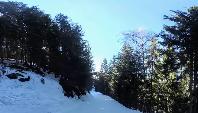
On paper (and on the piste map), the Montchavin piste Route des Bauches blue run sounds like a long, enjoyable excursion through the outer reaches of the main area. The reality is slightly different. Yes, this piste is long – but at times you’ll likely end up wishing it was shorter. This blue run definitely rates high on the La Plagne pistes to avoid list.
Affiliations: La Plagne 360 works with trusted, industry-leading suppliers to bring you the best services for your trip. If you click on these links, we may earn a small commission at no extra cost to you. In most cases, you’ll also benefit from a better deal. We only feature products and services we’ve used and genuinely recommend.
La Plagne intermediate piste Route des Bauches
The Route des Bauches is a very long, very flat pathway along the valley floor below the Plagne Bellecôte / Roche de Mio sector and the Bellecôte glacier which gradually curves around until it reaches the front into the main Montchavin sector ending near the Vanoise Express cable car. You will frequently have to unclip and walk or schuss along the flatter sections. Unless cross-country is your thing, you’d be best advised to steer well clear.
- Backcountry feel
- Very quiet (but for a reason)
- Far too flat
- You will end up walking
- Difficult to get back
- More like a cross-country run
- Unless that your thing, you should avoid
La Plagne accommodation deals
Route des Bauches Preview
Route des Bauches 360 VR

Route des Bauches 3D animation
Please subscribe to our YouTube channel for more videos like this.
Route des Bauches options at base
| Connecting lifts: | Connecting pistes: |
| Vanoise Express cable car | Mont Blanc blue |
| Montchavin red (via Mont Blanc) |
Route des Bauches piste stats
| Length: | 3.7km / 2.3m |
| Start alt: | 1830m |
| End alt: | 1574m |
| Vert drop: | 322m |
| Max gradient: | 26° |
| Graded: | Blue |
Route des Bauches Googlemaps
Closest webcams
Piste map local area

Weather forecast altitude