How the Jet Stream affects La Plagne weather

What is the Jet Stream
Although there’s more than one, the Jet Stream that affects La Plagne is a high-altitude air current flowing from west to east which plays a pivotal role in shaping the weather patterns of Paradiski and the wider Alpine region. Below is a look at how the Jet Stream affects La Plagne weather.
Affiliations: La Plagne 360 works with trusted, industry-leading suppliers to bring you the best services for your trip. If you click on these links, we may earn a small commission at no extra cost to you. In most cases, you’ll also benefit from a better deal. We only feature products and services we’ve used and genuinely recommend.
The Jet Stream and the French Alps
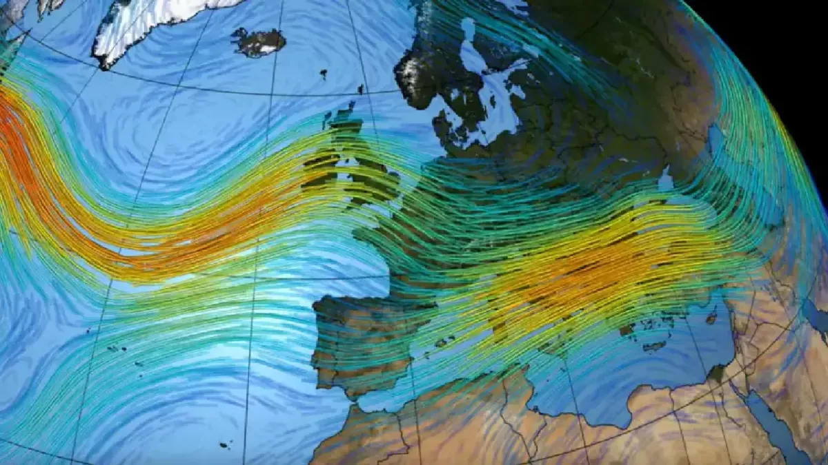
As it flows across the atmosphere, it brings moisture-laden air from the Atlantic Ocean towards the Alps. This moisture interacts with the cold air over the mountains, often resulting in heavy snowfall, particularly on the windward side of the ranges. Clouds laden with moisture are forced to ascend over Mont Blanc, causing them to cool and release precipitation in the form of snow.
If you look at the path of the typical Jet Stream, you could be forgiven thinking the Savoie and Haute Savoie mountains were almost ‘built’ on purpose (see image above). As moisture barrels in across the Atlantic, clouds form that then slam into some of Europe’s highest peaks giving them no choice but to rise. As we all know, when clouds rise they deposit moisture – and with the colder winter temperatures, this moisture falls as snow.
The snowiest resort in France
The pre-Alps on the French side rise gradually, increasing in height as they build towards the mighty Mont Blanc – so resorts in this path usually receive the most snow. In particular, the Dents du Midi range of the Portes du Soleil is normally the first and most significant mountain range which the clouds encounter. This (combined with the special Lake Geneva micro-climate) explains why Avoriaz is almost always the snowiest resort in France.
How does the Jet Stream affect La Plagne weather
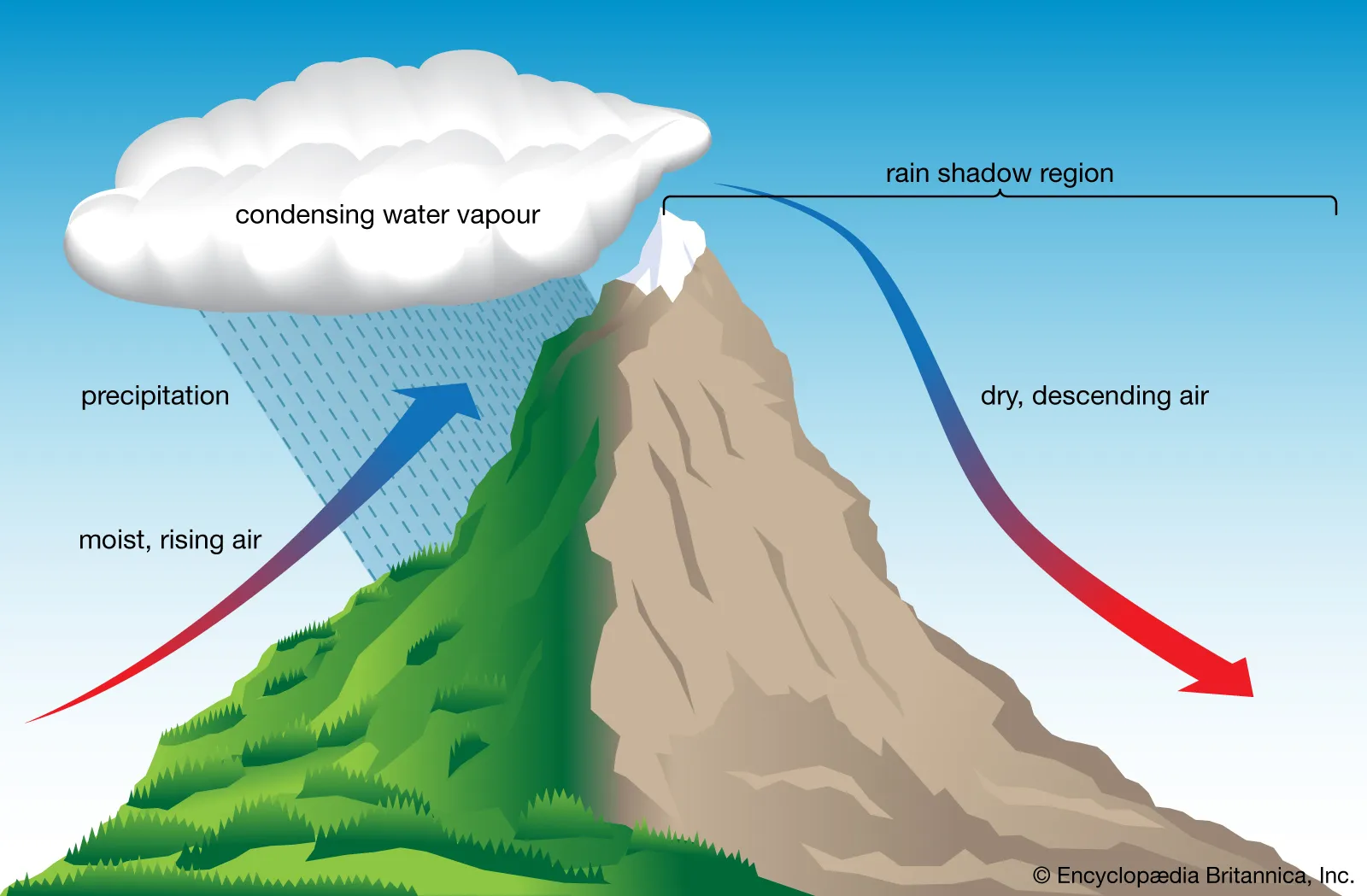
While the Dents du Midi range is usually first in the firing line for a typical Jet Stream dump, depending on the strength and direction of the Jet Stream, things are far from over as the clouds are pushed further into the mountain ranges. As these moisture-laden clouds progress further into the higher Alpine terrain, they have no choice but to deposit snow. This phenomenon is known as Orographic lift.
If the Jetstream is playing ball, it’s clear to see how this weather brings snow to the main Tarentaise resorts.
Orographic Lift: A Key Mechanism

Orographic lift occurs when air is forced to rise over mountain ranges, leading to cooling and condensation of moisture. The pre-Alps on the French side of the Alps provide a gradual ascent for air masses, allowing ample time for moisture to condense and form snow. In contrast, the Italian side experiences steeper relief, leading to less precipitation. In particular, the Po Valley often acts as a barrier, inhibiting moisture-laden air from reaching the mountains. There is, of course, one highly notable exception to this general rule – the famed Retour d’Est.
The Retour d’Est phenomenon
A Retour d’Est occurs when cold air from the northeast meets moist Mediterranean air, leading to intense snowfall. They are usually caused by a low pressure forming in the Gulf of Genoa then sweeping up the Po Valley, where they hit the steep mountainside.
The effect is most keenly felt on the Italian side, the southwestern Alps and usually as far as Val d’Isère’s Le Fornet (sometimes even reaching La Plagne). The phenomenon can be so intense that 2m falls are not uncommon in the more southern resorts – but the dumps are so heavy that often the clouds have dissipated before they move further along the Isère valley. To get a better idea of this region, take a look at 3D video of the Tarentaise resorts.
Follow La Plagne 360 on Social media
FB: https://facebook.com/LaPlagne360
T/X: https://twitter.com/LaPlagne360
YT: https://www.youtube.com/@iRideSkiSnow
See our La Plagne blue piste guides
To see a selection of the best blue pistes in other areas of La Plagne, check the links below for more information and route videos.
Plagne Bellecôte best blue pistes
Grande Rochette (Plagne Centre, Plagne Soleil, Plagne Villages) best blue pistes

