La Plagne drone tour
A drone tour of La Plagne
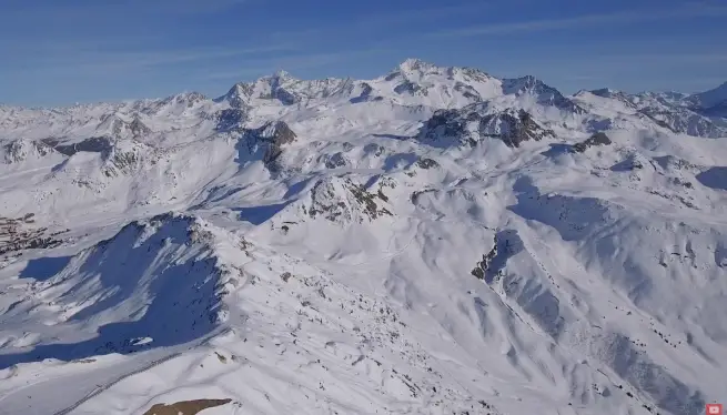
This short drone flight gives you a real sense of La Plagne’s scale and layout. Filmed from both Roche de Mio and Grande Rochette, it sweeps high above the main villages and lift hubs, showing how the resort fits together on the mountain. You’ll fly over Plagne Centre, Plagne Villages, Plagne Soleil, Aime 2000, Plagne Bellecôte and Belle Plagne, revealing connections you don’t always notice from the pistes or lifts.
A drone view lets you see the resort in a way maps simply can’t. Lift lines, terrain changes and village spacing all make much more sense from the air. This is a La Plagne tour by drone.
Affiliations: La Plagne 360 works with trusted, industry-leading suppliers to bring you the best services for your trip. If you click on these links, we may earn a small commission at no extra cost to you. In most cases, you’ll also benefit from a better deal. We only feature products and services we’ve used and genuinely recommend.
Why a drone view actually matters
The majority of La Plagne is spread across two wide mountain bowls, and the relationships between villages are not always obvious on the ground. A drone view makes those connections immediately clear. This is particularly useful if you’re:
- Deciding where to stay in La Plagne
- Trying to understand how lift hubs link together
- Planning full-day routes rather than staying in one sector
- Working out whether ski-in ski-out access really matters for your trip
If you’re still getting your bearings, combining this video with the La Plagne piste map or our See La Plagne in a Day route gives a much clearer picture of how the resort flows. You could also check this 3D video of La Plagne villages and topography to understand the area better. Note – some of the lifts in this video have been upgraded since filming. Everything else has stayed basically the same.
Plan your trip
More La Plagne travel resources: These partners help with booking, transfers and kit hire. We may earn a commission if you use them – at no extra cost to you.
La Plagne Geneva flights
More La Plagne flights